Airsurveys of breeding and wintering Steller's sea eagle at Kamchatka: successes, failures and perspectives
By Alexander LADYGUIN
Science Park of Moscow
State University
Russian Federation

|
Airsurveys of breeding and wintering Steller's sea eagle at Kamchatka: successes, failures and perspectives By Alexander LADYGUIN Science Park of Moscow
State University |
|
Contents: (brief version) Introduction. Specific of air survey at Kamchatka Brief historical review: scope of the areas, covered by helicopter surveys Technique methods, tools and techniques, strategyes disadvantages) Results: account of the flight hours, quantity of birds, nests, distribution of the surveys by seasons breeding: - status - distribution wintering: - status - distribution Perspective of future monitoring of a populations |
|
Summary |
|
The regular airsurveys of large birds of prey have begun on Kamchatka from the beginning of 80th. For the surveys the various types of air crafts and various techniques and strategies were used, the disadvantages and advantages of which are discussed in the presentation. Now more than 520 SSE and more than 20 WSE nests are mapped, inspected more than 120 ooo square kilometres, the data about preferred by raptors habitats are systematized. The most full inspected are the following areas: a valley of the river of Kamchatka, east coast of a peninsula from cape Lopatka up to Ust-Kamchatsk, the river Elovka basin. If it is possible to recognize results of the surveys of the breeding birds as satisfactory and representative, almost northing known about the status and distribution of wintering birds, that now is the most dangerous blank in our knowledge of raptors ecology. Therefore most urgent actions on monitoring of the SSE population at Kamchatka is the organization of the global winter surveys. |
 |
|
The survey of large birds of prey at Kamchatka has some specific which strictly determine methods, technique and schedule of surveys.
|
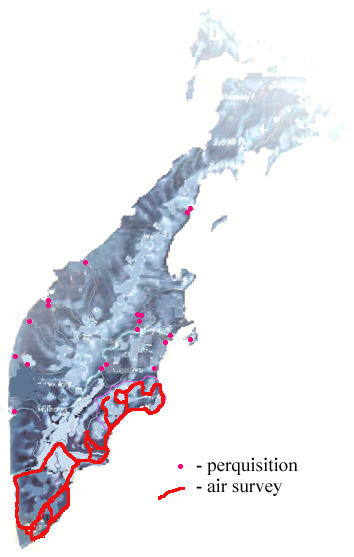
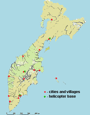 Fig1. Location of the helicopter bases and main people settlements
in Kamchatka
Fig1. Location of the helicopter bases and main people settlements
in Kamchatka |
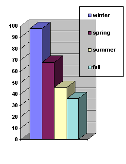 Fig4. Percent of recognised eagle nests at the model area in a different seasons |
The indicated features with necessity dictate:
usage of the helicopter for the surveys, unacceptability of
alternate methods of the surveys, a very short and strictly
limited time assigned for the surveys - prior to
the beginning of the appearance of foliage on trees, which,
as have shown special researches, not only hides contents of
the nest, but also increases mistakes of the survey at this
time of the year up to 60%.
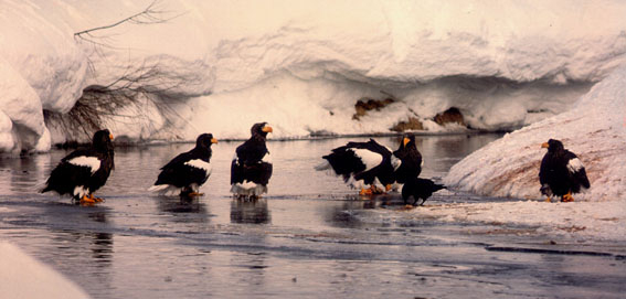
Productivities of the winter surveys (I mean the time of the year with snow cover, which still present at Kamchatka at the beginning of June) comes nearer to 100%, summer and even the spring surveys made on the model splots have shown, that their efficiency approximately have 65%. High percent of mistakes during summer surveys depends on the difficultes of recognition nest withing canopy. |
|
|
Nevertheless, some areas, due to their
extreme inaccessibility, has appeared almost not covered by these
surveys. This is the area of western Kamchatka from the river
Vorovskaya to the north and north-eastern part of Kamchatka from
the line between the river Tigil and river Ozernaja. |
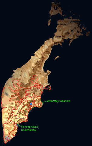 Fig2. The map of summer air surveys have done at Kamchatka during
1984-1998
Fig2. The map of summer air surveys have done at Kamchatka during
1984-1998 |
|
|
|
During last decade at Kamchatka a
different methods and different strategy of surveys were used.
As was shown, the land and motor boat surveys are extremely
ineffective
on Kamchatka due to their exclusive complexity. In the beginning
of 80th years in Kronotskyi reserve were applied double during
a season land surveys of a model population in territory about
12 000 square kilometers. However, was remarked, that the visiting
of the nests in spring period, that is in the beginning of period
hatching has an extremely negatively effect for final success
of reproduction of birds, resulting to increased of eaglets
dearth. Therefore in subsequent it was necessary to refuse from
land survey of the nests in the spring and made it from
helicopter. Then, the result of breeding success in the nests
examined in the spring, was checked in August by land survey. Such strategy,
first, save our time and force, because we know which one nest is living
before land visiting (which is difficalt in Kamchatka landscape, of course),
second, save money for second helicopter survey, third, we have opportunity to
check eaglets, describe the nest, food, remains, ets. The application of such strategy looks the most productive in conditions of the limited financing for the helicopter survey. Actually, the technique of the air survey did not differed from common practice, unless by that we had no possibility to use neither GPS tools, nor any navigating systems, nor computer simulation of the processes occurring in a population. Normally, we used small helicopter Mi-2 and fly with speed about 150 km/hour 50 m above the land. All nests were mapped at the mape 1km in 1 cm scale and describing. |
|
|
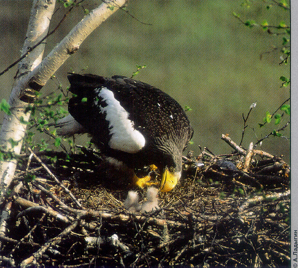
Breeding status Totally in different years more then 525 nests of SSE are accounted. More than 60 characteristics both the nests and surrounded habitats were used for nests' description. At the moment these data are in processing, but we hope, that in the nearest future we can use the database for understanding the features of habitats which determine the choice by birds for nestling and other preferences. The main surprise of 1996 survey was the extremely high nest density at the two plots: Elovka river and at the north-west coast of the Peninsula.Living nests were concentrated exectly along narrow river basin and were sometimes just 200 m from each other. Totally at Elovka were estimated 58 living nest per 100 km and 48 living nest per 100 km were account at North-west (absolutely it was 29 nest at Elovka and 39 nest at north-west). In compared, at east coast we estimated 15 living nest per 100 km. Kamchatka river basin has a low density of eagle population due to high level of different kinds of human activity. Totally, about 45 pairs of eagles (both SSE and WSE) nesting here. |
 |
|
Distribution during nestling. The types of habitats structure were determined on the base of the following characteristics, which were used for computer analisys of habitat's preferences: A. Used landscape type (macrohabitat pattern) [investigated area in a square km] 1. low river valley [751] 2. high river valley [45] 3. top of the river valley (platou) with birch forest [347] 4. tundra with certain forest islands [81] 5. flat tundra [93] 6. sea shoreline [218 km] 7. old mixed coniferous taiga [541] 8. birch forest outside river basin [219] 9. mursh land [421] 10. mountain tundra [387] 11. rocky mountain [372] 12. agricultural land [291] 13. alpine zone with low bush 14. large old volcanic-glacier lakes(Kuril,Kronotskoe)[125] 15. old voulcano caldera with forest and water reservouir within [24] |
|
B. shore line landscape: 1. Rocks and clifs used by sea birds2. High latitude rocky coast with short litoral and covered by the bush on the platou, usually with numerous small river 3. Rocky coast without woodland and river valley 4. The sloping mountainside covered by bush 5. Flat tundra or woody coast with bank 6. Flat grassland or mursh with(or without) certain small wood island 7. Shallowed gulf and lagoon: - with wooded coast - with mursh coast 8. Grassland and mursh in basin of large river with the net of small streams , lakes and creeks. C. litoral bottom characteristics D. vegetation on the shoreline within 300 meter strip - single species, mixed- age - continuosness: continuos forest, fragmented, certain forest lands E. type of the water reservoir: sea, lake, river, salt lagoon F. feeding site: - distance from the nest site,- presence/absence of tidal currents, - flood pattern - transparency of water - presence/absence of underground springs - available prey list - presence/absence salmon spowning grounds - food availability and abundance - period when food is available - avarage size, - depth, - landscape of bottom, - ice condition - abundance of perch and place for roosting - protection against strong whether conditions |
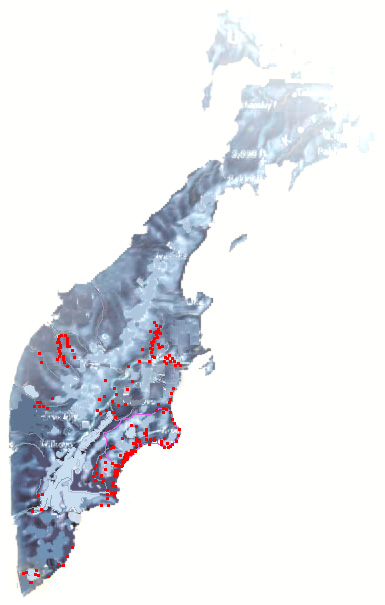
Fig. Nest distribution of SSE at Kamchatka |
||||||||||||||
|
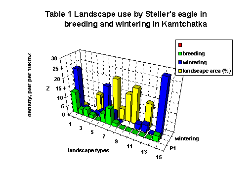
G. type of nestling river valley: - deep wide valley covered by old forest- deep narrow valley covered by old forest - flat murshland valley with certain wood island - flat tundra and mursh land without any vegetation - flat tundra valley with poplar forest band by the stream H. nest location: 1. on the treetree characteristics: - species, - class: dominant, subdominant, - age: old, middle, young - quality: live, dead, crashed - distance from the forest boundary - distance from the water boundary - distance from the feeding site 2. on the rock I. stream pattern 1. salt or fresh2.absence/presence(number) of salmon spowning grounds, 3. physical characteristics - depth - width - stream speed - transparensness - open/wood covered - presence/absence of gravel bars, small open islands - bottom feartures - temperature L. Coast pattern - flat or breaked coast line, - absence/presence of small islands, - absence/presence lagoon, - steep-walled coast, - wooded/bare Habitat characteristics were compared using single-classification analysis-of-variance and Mann-Whitney rank sums test. Stepwise logistic regression was used to determine which habitat characteristics best distinguishied between used and unused areas (and high and low used areas) for all revealed habitats combined and for each habitats separetely. A characteristics were used in the regression model if comparisons between used and unused areas produced an F-statistic of P<0.01. To reduce redundancy with other characteristics , only one pair of highly correlated (P<0.005) characteristics was used in the model. Use of landscape. The first step of the research was to determine the number and the features of eagle distribution in variable Kamtchatka landscapes The strong selected (i.e. habitat selection occurs) both nesting sites and wintering locations were showed (table 1).
The most preferable both for nesting and wintering are low river valley landscape type and rocky sea shoreline. Additionally for wintering the large old volcanic lakes is the most important. The next step of the research was to determine the reasons of non dispersal distribution of eagles. There are two common hypothesys: 1. Mosaic distribution is the result of strong demand either to the nest sites or to the food base location. 2. The next one reason is the differentation in the level of human activity in a different habitats. Nest site use. Within landscape type eagle shows a high variation in nest site use. We estimated both all nest sites characteristics combined and separately within each type of landscapes. This analysis shows that eagles use for nesting any sites which are available, i.e. there is no any selection of nest site withing selected landscape type. 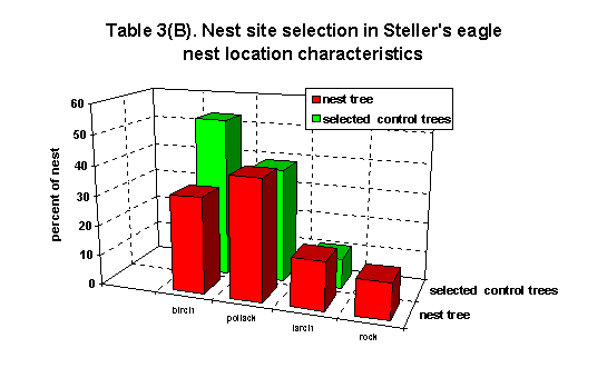
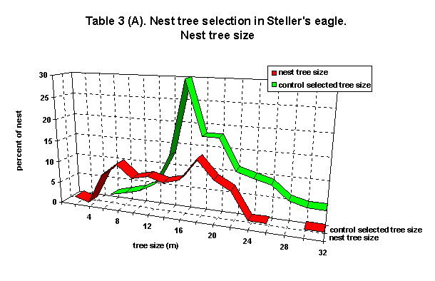
Nets tree selection Surprisently, nest tree selection was not found in Stellers eagle, like it is normall for another raptors. There is no some preference neither in tree size, nor age, nor tree species, nor tree construction.
- distance from the forest boundary - distance from the feeding site ( but this characteristic was more variable) - presence of salmon spowning grounds When shoreline was selected as nesting site, the significant preference of coast with gulf and lagoon was showed. There was no significant preference in any other type of shoreline. There are no some significant preference in C, D, E characteristics (litoral bottom, vegetation on the shoreline, type of the water reservoir), i.e. Steller's eagle demonstrait a very high diversity in used habitats and their characteristics. So, we can conclude, that inspite of strictly landscape selection ocurrs, eagles select home ranges in a very different types of habitats with high diversity of physical characteristics.
If the main our objective is to find the real and working method to control eagle population, we have to run new strategy of our researches. I support the idea to organise the long-term all year round investigations of the factors limiting SSE surviving. It must be new level of investigation, comprehensive and complexly. The following acts I am consider as the high-priority for future monitoring of SSE population at Kamchatka: First, It is impossible to grasp immense, Kamchatka is too large to cover all the territory by helicopter surveys both at winter and summer. So, we have to use the model research base station for long-term research. The Kronotskiy Reserve territory looks the best for this goal, first of all, because of there is population which is under control during last 20 years here and we have the detail information about the life of more then 60 nests. Also, it is good known area with developed research station and wide net of local cabins. Also, at this territory a long term research of Pacific salmon are made by Salmon Institution. What kinds of reserach this project must include: I gess, we have to focus our efforts at the free kinds of problems:
1. The new global winter airsurveys. 2. Mass marking of eaglets. 3. Marking the adult birds on wintering sites both at Kamchatka and Japan. 4. I am not support the idea to continue summer airsurvey. | |||||||||||||||